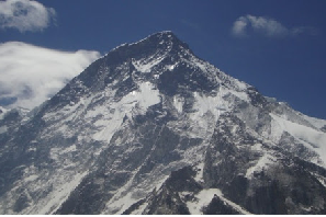
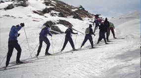
Bagini Glacier
- Region: Ladakh
- Trek Duration: 6 Days
- Trek Difficulty: Difficult
- Max Altitude: 14711 ft.
Bagini Glacier
The course which takes you to the Advance camp taken for mountaineering endeavors to High running pinnacles like Changbang and Kalanka gives you a vibe of being in Everest Base Camp without it's buzzing about of congestion and commercialization. As of late with the expansion number of adventurers picking to investigate the campgrounds of Bagini and Changbang than the more well known Dharansi Pass Trek from Nanda Devi Outer Sanctuary (NDOS) domain, it is a reasonable suspicion that Bagini Glacier journey is practical choice for bold voyagers and hikers who need to investigate and find out about the mountains of the district.
History About Bagini Glacier
The twin pinnacles of Nanda devi and Nanda devi east(7,434 m) ooze a quality incredible by any mountain in the Indian Himalayas. Lying altogether inside Indian boundaries Nanda Devi is barely shy of being a 8 thousander, yet that has not been an obstacle to its loftiness nor it has been a hindrance in its worship. Climbed first in 1937 by unbelievable climber and pioneer Major Harold William Bill Tillman otherwise called H.W Tilman and acclaimed Noel Odell, (Noel was the last first individual to see Mallory and Irvine as far as anyone knows climbing the Second step on Mount Everest on eighth June 1924) its tryst with investigation returns to 1930s when a number to undertakings over and again neglected to reach even its base. The justification behind this lying in the way that the principle highest point is encircled by an impervious obstruction of pinnacles. The normal tallness of this hindrance being 20000 ft, the tag invulnerable is perfect.
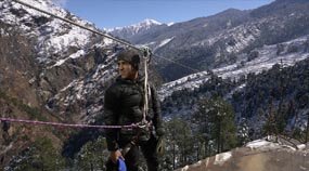
The Nanda Devi National Park is a public park arranged around the pinnacle of Nanda Devi. The recreation center includes the Nanda Devi Sanctuary, a chilly bowl encompassed by a ring of tops between 6,000 meters (19,700 ft) and 7,500 m (24,600 ft) high, and depleted by the Rishi Ganga, through the Rishi Ganga Gorge, a lofty, practically closed debase. The whole park lies at a height of in excess of 3,500 m (11,500 ft) above mean ocean level.Some of the tops in this asylum are Dunagiri, Kalanka, Changabang, Rishi pahar, Nanda khat, Nanda Ghunti, Panwali Dwar, Trishul and so on After many bombed undertakings and ardeous investigations in 1934, British pioneers Eric Shipton and Tillman discovered a course inside the safe-haven through the Rishi Gorge. Nanda devi primary (7786m) is encircled by a thick mass of tops, there is an inward divider just as an external divider. Bagini glacial mass deceives the North of this external divider. Bagini icy mass journey is a short trip, it tends to be done inside 5-6days. The trip begins from Jumma a little town on the Joshimath Malari thruway which is around 40 km. From jumma its a 2-3 hour simple climb to Ruing. From Ruing it is a continuous steep climb to a spot called Chaza which is without any vegetation, after which there is a precarious climb over avalanche zone to the Alpine town of Dunagiri. From Dunagiri it is a multi day climb to Bagini icy mass and Changabang headquarters.
- Day 1: Jumma to Ruing village (2800m)
- Day 2: Ruing(2800m) to Dronagiri Village (3610m)
- Day 3: Dronagiri Village (3610m) to Bagini B.C (4484 m) via Longatulli (3800m)
- Day 4: Bagini base camp(4484) to Changabang base & back to Bagini B.C
- Day 5: Bagini B.C to Ruing
- Day 6: Ruing to Jumma by trek, jeep drive from Jumma to Joshimath
Day 1: Jumma to Ruing village (2800m)
The trip begins from a non descript town called Jumma which is an hour ride from Joshimath.Trek Ration and lamp oil can be gotten from Joshimath, as further up things get dearer by the meter. The ride from Joshimath to Jumma is part rough and part smooth. Tapovan, Reni, Lata, Suraithota, Phagti are numerous towns which fall coming. In the middle of Suraithota and Jumma the street is in standard with the Dhauliganga stream, which makes it a decent watch in pre-winter, however will certainly play devastation during the pitiless storm months. Assuming you need to stack lamp fuel Suraithota is a decent choice.
Jumma is close to the tibetan line so during evening there will be a furious breeze, brushing you off your feet when you land from your vehicle. The path begins with a steel engineered overpass over the Dhauliganga after which the climb of Ruing starts. The way to Ruing is somewhat steep through the woodland. Its around 3 kms from Jumma to Ruing and will not require more than 2-3 hours. Remaining at Ruing is a bit precarious, you can remain at the panchayat ghar. In the event that the town elderly folks license the journey group to camp there for the evening, all things considered another alternative is to climb further 2-3 km from Ruing and arrive at a little prairie not long before the rising of Dronagiri. The spot enjoys two unmistakable benefits, one you draw nearer to Dronagiri and it would be simple for you to arrange the gigantic move through the avalanche and second this spot has a close by stream so a decent regular spot to camp.
Day 2: Ruing(2800m) to Dronagiri Village (3610m)
Starts with a similar sort of trail ( trail from Jumma to Ruing). Its a very much laid way through the timberland now and again wandering up and some of the time down. There is no chance of somebody to get lost here. This a singular path with little or immaterial sideways. A good ways off of around 3.5mtrs from the Campsite, you arrive at the start of the avalanche zone. You notice two unmistakable path, one on the upperside and another descending. Try not to accept the upper one as it is a remainder of a previous path that used to be the fundamental path to the town. Yet, it was obliterated a few years prior by gigantic glacial masses from the Nandikund region. This has prompted the creation of something of a small scale Canyon which will need the support of an aide or watchman to arrange in case you don't know footed.
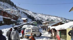
The path is dusty, steeply leaned at a point of 60° to 70 º to the level and loaded with mud slides, little streams confusing your way, while you take your drained body clearly and gradually to the top. When you reach there, an established asphalt anticipates in quiet expectation to take you to the Village. The scene is straight out from a Swiss high scene. The skyline is spotted with the snow loaded pinnacles of Hathi Parvat, Ghori Parvat. In the event that its mid year, blossoms will be in full bloom. For probably the first time you fail to remember this isn't a journey however a stroll in the Swiss alps. Be that as it may, reality occurs to you rapidly as you will step by step see the run down places of Dronagiri, a large portion of them will be uninhabited, and those not will appear to you are from a time long since past. There are no shops in the town, the closest market is at Suraithota right around 20 kms away, however there is a shop in Ruing yet it is incredibly fundamental.
Setting up camp alternatives in Dronagiri are restricted to two. One in the town edges and one more in the GMVN which is approaching fruition. Costs in remaining there, will go from Cheap to through and through expensive contingent upon how you and your aide can haggle with the Chowkidar. In case you are not from be prepared to pay a robust total. This pre-winter it cost 1500 for one space for two travelers from England. Two astonishment penetrations of Technology are the presence of satellite telephone in the town which costs around rupees 2/every moment for a neighborhood call inside Uttarakhand. In any case be ready to be met with despondency. Satellite telephones here are inclined to glitch or not work at all and exposed to the impulses of the town telephone administrator, one more is sunlight based lights ,the town is spotted with sun powered tubelights and sun oriented streetlamps. There is a sanctuary of the Bhumial God arranged on the higher compasses of the town which is respected and venerated by the neighborhood people. From the town, the main perspectives on the Dunagiri mountain is noticeable.
Day 3: Dronagiri Village (3610m) to Bagini B.C (4484 m) via Longatulli (3800m)
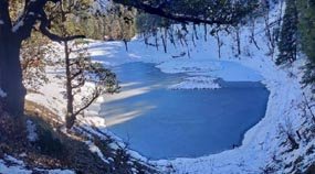
In the wake of leaving Dronagiri we arrive at a wandering way which drives us to a high edge from where the primary perspectives on the Rishi top is noticeable. Bagini nala too is first noticeable from here. Around 30 mintues after we left the town we arrived at a substantial extension over the Bagini Nala. Try not to accept the left path as it paves the way to the Kanari khal and afterward steadily towards Garpak town. Subsequent to intersection that connect the way again takes a wandering turn upwards. The region here is totally without any vegetation. Its rocks and a greater amount of stones which fill the scene. There is a fix of green next to a stream which we reach following an hour and a short ways from the extension, This is a decent setting up camp ground. Further an hour more we arrive at the setting up camp ground of Longatulli which is again an excellent camping area, People who are as yet not acclamatized can stop here for the afternoon. The course from Longatulli is rising. Its not steep yet it continuosly climbs with rocks coming. After around 2 to 3 hours of climbing you arrive at a plain level which is the Bagini Lower Base Camp(12360 foot). A considerable lot of the pinnacles which are visibe from here are Rishi pahar, Satminal, Hardeul and so on Bagini Upper headquarters is again around 4kms from here. From Bagini Upper headquarters a ways off of around 30 – 45 mintues, there is a superior setting up camp spot called Bagini Advanced Base camp(15530 ft).The trail is basically something similar all through ,climbs gently all things considered spots, steep at not very many spots. Attempt to cross the bagini nala/garud stray/garud stream promptly toward the beginning of the day, in light of the fact that as day the advances so does the volume of water. Intersection the nala in the early evening isn't prudent. The course isn't very much checked particularly for the fledgling traveler yet a cautious look will give you seeing cairns, little stones situated one on top of the other with the goal that you can find your path. You can camp at both of the spots for the evening.
Day 4: Bagini base camp(4484) to Changabang base & back to Bagini B.C
You need to start early in the event that we need to get dawn from Changabang headquarters, which is around 3-4 kms from Bagini Advanced Base Camp. Leave your backpack in the headquarters and convey just the vital accesories. From Bagini Advanced Base camp the course to Changabang headquarters again climbs. The street is brimming with moraine, and you will detect various precipice on the bagini ice sheet.
Changabang headquarters is a colossal amphitheater. The pinnacles which are apparent from here are Hathi(6507m), Ghori,Satminal(6911m), Dunagiri east(7066m),Garur top, Trishuli(7057m), hardeul(7323m), Rishi(6099m), Kalanka(6931m), Changabang(7174m). We return the same method to Dronagiri Village where we camp for the evening.
Day 5: Bagini B.C to Ruing
We return to Ruing by a similar way. Take a jeep from Jumma to Joshimath and continue for Haridwar.
Day 6: Ruing to Jumma by trek, jeep drive from Jumma to Joshimath
On last day, jeep drive from Jumma to Joshimath
Inclusions:
1. Accommodation. (Guest house, Home stay, Camping)
2. Meals while on trek (Veg.+ Egg)
3. Trek equipments: Sleeping bag, mattress, tent (twin sharing), kitchen & dinning tent, toilet tent, utensils and crampon (if required)
4. All necessary permits and entry fees.
5. First aid medical kits, stretcher and oxygen cylinder.
6. Mountaineering qualified & professional trek Leader, guide and Support staff.
7. Transport from Dehradun to Sankri and return (According to itinerary)
8. Mules to carry the central luggage
Exclusions:
1. Any kind of personal expenses.
2. Food during the transit.
3. Insurance.
4. Mules or porter to carry personal luggage.
5. Anything not specifically mentioned under the head.
6. Any kind of emergency evacuation charges.
Note:
Charges of offloading backpack:-
INR 1200/- if you make an online payment, 10 days in advance
INR 1500/- if you inform us after reaching Sankri
The backpack cannot weigh more than 11 kgs. Backpack should have waterproof cover. Suitcases/strolleys/ bags will not be allowed.
To book Kedarkantha Trek/ adventure program please use our online booking form or, alternatively, you can call us on the given for confirmation of tour you have to wire a deposit and initial deposit.
Paying the Trek/ Adventure activity fee:
The fee can be paid by online transfer/check deposit/ demand draft. Instruction for payment will be forwarded along with your confirmation email. When your transfer is done, please e-mail us a confirmation mail with your transfer details, so that we can follow up your reservation efficiently.
When to Book:
It is wise to make your booking at least two months in advance. However, if you want a good deal on your domestic/international flight, we recommend organising your trip at least five months in advance. (Please contact us if you require a late booking)
Cancelation Policy:
1. Accommodation. (Guest house, Home stay, Camping)
2. Meals while on trek (Veg.+ Egg)
3. Trek equipments: Sleeping bag, mattress, tent (twin sharing), kitchen & dinning tent, toilet tent, utensils and crampon (if required)
4. All necessary permits and entry fees.
5. First aid medical kits, stretcher and oxygen cylinder.
6. Mountaineering qualified & professional trek Leader, guide and Support staff.
7. Transport from Dehradun to Sankri and return (According to itinerary)
8. Mules to carry the central luggage
Trekking Gear
1. Ruck sack bag with rain cover. Qty -1
2. Day Pack Bag - Recommended for treks with summit day
3. Head Torch with spare Batteries. Qty -1
4. U V protection sunglasses. Qty -1
5. Water Bottles: 2 bottles of 1 liter each
Footwear
1. Non-skid, deep treaded, high-ankle trekking shoes Qty -1
2. Pair of light weight Slipper/Sandals Qty -1
Clothing
1. Quick Dry Warm lower or Track Pants. Qty - 2
2. Full sleeves T-shirts/ Sweatshirts. 1 for every 2 days of trekking
3. Pair of thick woolen socks. 1 pair for every two days of trekking
4. Thermal Body warmer Upper & Lower. Qty-1
5. Undergarments. Qty - 1 for every day of trekking
6. Warm jacket closed at wrist & neck .Qty-1
7. Full sleeves sweater. Qty -1
8. Rain wear ( Jacket & Pants ) . Qty-1
9. Pair of waterproof, warm gloves. Qty-1
10. Woolen cap. Qty-1
11. Sun shielding Hat. Qty -1
Toiletries
1. Personal toiletries kit (Small Towel, Toilet paper, paper soap, Bar soap, toothbrush, toothpaste, cold cream etc.)
2. Sun screen lotion small pack . Qty -1
3. Lip Balm small pack. Qty-1
Utensils
1. Small size, Light weight & Leak proof lunch box. Qty-1
2. Plate. Qty- 1
3. Spoon.Qty-1
4. Tea/Coffee (plastic) Mug.Qty-1
Miscellaneous
1. Camera (Optional)
2. Carry your medicines in plenty in case you have any specific ailment. Consult your doctor before joining the trek.
3. Dry fruits, Nuts, Chocolate bars (Optional)